
Description
Details
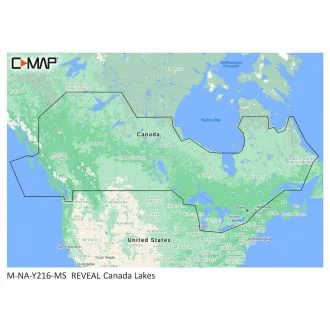
The premium mapping solution for cruisers, anglers and sailors looking for accurate, quality data with game-changing shaded relief from the market-leader.Cruising, fishing or sailing, C-MAP® REVEAL™ Lakes charts offer the very best of C-MAP. With Shaded Relief, including game-changing Reveal Seafloor Imagery, Aerial Photography and Satellite Overlay presentation added to the core C-MAP features found in DISCOVER™ – full-featured Vector Charts, with Custom Depth Shading and subscription-free Easy Routing™. It also includes the very best of C-MAP High-Res Bathy, including integrated Genesis® data. Purchase includes a full 12 months of online updates.
Compatible with Lowrance, Simrad & B & GChartplotters. SD/Micro SD Card
Features:
• Shaded Relief – bring the world around you to life, with 3D rendered land and underwater elevation – including areas of Ultra-High-Res Bathymetric imagery – a game-changer for anglers and divers.
• Full-Featured Vector Charts – making navigation easy by giving you accurate, up-to-date vector chart detail derived from official Hydrographic Office information.
• High-Res Bathy – helps you identify shallow areas, drop-offs, ledges, holes or humps. Now includes compiled and quality-controlled Genesis® detail as part of singular HRB layer.
• Custom Depth Shading – set a clear safety depth, maintain a paper-like view or create your own custom shading.
• Easy Routing™ – helps you automatically plot the shortest, safest route based on detailed chart data and your personalized vessel information.
• Aerial Photography – a collection of thousands of photos of marinas, harbors, inlets and other notable navigational features included to offer an additional level of detail.
• Satellite Overlay – satellite imagery gives information about the surroundings when you find yourself in an unfamiliar place.
• Harbor & Approach Details – unprecedented level of detail. Approach any harbor and inlet with confidence.
• Online Updates – keep your chart up to date, with 12 months of free online updates.


Reviews
There are no reviews yet.